The last time I reviewed a stand alone GPS data logger it was the GlobalSat DG-100, a functional but not very stylish box for recording GPS tracks.
The new i-gotU GT-600 GPS Travel & Sports Logger from Mobile Action (disclosure: they sent it to me for free) has the same SiRF Star III chipset as the DG-100, but it comes in a smaller and more attractive package.
You’ll want a GPS data logger if you want to record your travel and sports tracks (walking, running, cycling, sailing, etc) and tag your photos with their GPS locations. Recording this GPS information will allow you to examine your route on the computer later on, and see exactly where you were when you took your photos.
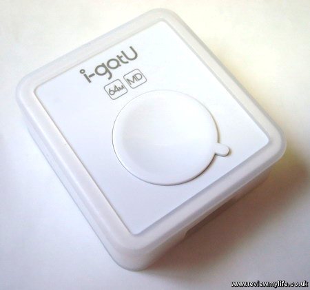
i-gotU GT-600 hardware
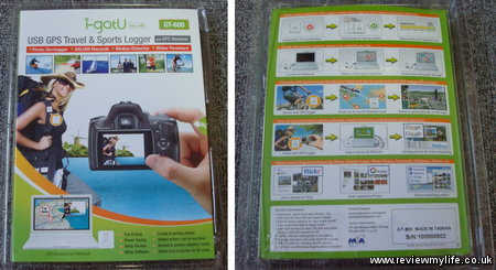
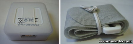
The GPS measures just 46×41.5x14mm and weighs only 37g. It is made of shiny white plastic, and there is a soft plastic case around it (presumably to protect it if you drop it). Here is what the packaging looks like from the front and back.
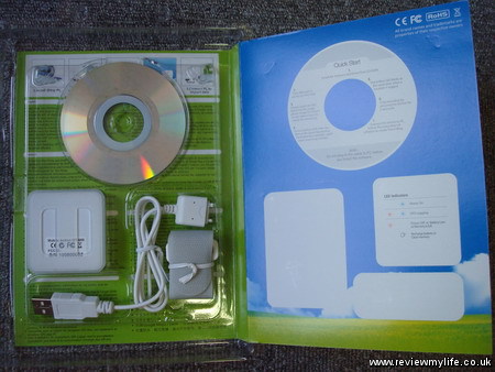
And this is what is inside the packaging. You get the GPS data logger, a USB cable, a velcro strap, and a mini install CD. If you have Windows 7 you won’t need the CD – you will have to download the software from their website.
Here is a closer look at the sides of the unit. On one side is the cable connection, and on another there is a hole which you could use to attach a wrist strap.
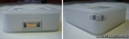
Here is the underside of the unit, the holes in the casing are there for you to feed the velcro strap through.
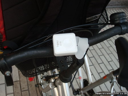
The velcro strap allows you to attach the GPS unit to your rucksack, bike, boat, etc. Ideally you should have the unit positioned so that the front faces clear sky. Here is the unit strapped to my bike, ready for a cycle around the city.
i-gotU GT-600 in use
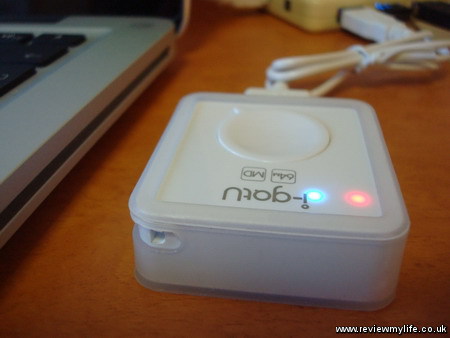
There is only one button on the GT-600. Just hold it for a few seconds and a blue LED (under the plastic) will light up. You then need to wait for 30-60 seconds for it to get a lock on the satellites.
How long it takes depends on how many satellites are above visible from your current location, and also on cloud cover. In ideal circumstances it could get a lock in about 30 seconds. The time will also be reduced if it was on in the last few hours as it will still know the positions of some of the satellites. Once it has a lock then both the red and blue lights will start flashing.
Once it starts recording you can do whatever you want; Walk, run, cycle, sail, and it will log your position every 5 seconds. The unit is water resistant so it should be ok to use in the rain.
Remember to check the unit’s flashing lights regularly to make it is still recording. It can be very annoying if you get home and realise that only half your journey was recorded because a thick cloud or other GPS signal blocker stopped the unit from logging your GPS tracks.
The battery lasts about 30 hours if you log every 5 seconds (longer if you increase the logging interval) and is charged by the same USB cable that you use to transfer the GPS data.
The unit can store 262,000 way points (locations) so if it is logging every 5 seconds this will be enough for 363 hours GPS tracks. More than enough for most adventures!
To make the battery and memory go further it has a motion detector built in. If you are still for a while (perhaps you have stopped for lunch for example) it will stop recording. They claim that this will give you an extra 20% logging time.
Holding the button for a few seconds will turn the unit off. Because the button is easy to press I’d recommend that you don’t keep the unit in your back pocket. If you do you may well accidently turn it off when you sit down, or bend over. Either keep it strapped to your rucksack, bike, or clothing using the strap, or be careful to place it so that the button won’t be pressed. I find it works fine when put in the front pocket of my rucksack. The logging might now be quite as accurate as it would be if it had a view of the clear sky, but it is good enough.
To sync your data to your PC you just plug it in via the USB cable and start up the @trip PC software.
i-gotU software
The i-gotU GT-600 GPS data logger comes with three pieces of software.
- @trip PC – which is the software you’ll want to use if you want to manage your trips and geotag your photos.
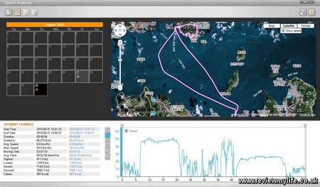
- Sports Analyzer – which shows your GPS tracks in a view that allows you to easily see average speed, calories burned, and when you did each of your activities.
- Where I am – which simply shows you where you are now on a map.
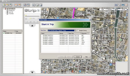
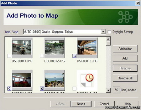
I’ve mainly been using @trip PC. After importing the GPS tracks you have the option to create a ‘trip’. A trip can consist of one or more GPS tracks along with the associated photos. If you have synced multiple tracks you can go back and create new trips for the other tracks later on without having to sync again.
You can choose which photos you want to include in the trip. When you’ve chosen them the software can add GPS location information into the image.
After creating the trip you’ll get something a bit like this. It shows you the route you took, and the locations of all your photos. You can ‘play’ the trip and watch a moving icon go along your route. The photos you took will pop up as the icon reaches them.
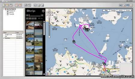
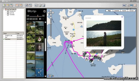
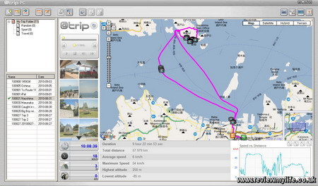
You can customise the look of your trip. The view above is the basic view, and the one below is a sporty view which shows a graph of your speed and a few sporty facts about your trip such as total distance, and average speed.
The @trip PC software is easy and quick to use for viewing your tracks and tagging your photos. The main thing it lacks is an sensible way to delete rogue way points (sometime you’ll want to manually clean up your tracks a bit). You can get a list of all way points, but when you have thousands of them it can take several minutes to find the one you want. The software should ideally let you select one or more way points by clicking on them to allow speedy moving or deletion.
In the version of the software I used (2010.06.09) there were some UI annoyances, and other problem such as slow syncing, and unreliable communication with the hardware – on my Windows 7 machine if you have done a sync, you can’t delete the data on the device unless you unplug and replug the device back in – you get a ‘Failed to clear log data. (Error=4)’. But you can work around all these issues.
If you are only interested in sports tracking and aren’t going to geotag any photos you can use the Sports Analyzer software instead. This is a simpler interface which just shows you your tracks along with speed, distance, calories burned etc.
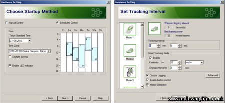
i-gotU GT-600 advanced configuration
Using the @trip PC software there are some advanced options you can configure. You can set the GPS unit to only record at certain times of the day. And you can set how frequently the unit logs your position.
Sharing your trip
If you don’t just want to keep your trip to yourself you can share it with just a few clicks. The @trip PC software can upload your tracks and photos to the @trip server. You have the option of uploading the photos to the @trip server (it will shrink the photos for you), flickr, or Picasa.
Your free @trip account only give you 100mb of space on the @trip server so I’d recommend creating a free Picasa account to your save your @trip account space for the GPS tracks. A Picasa account will give you 1024mb of photo space. Or if you already have a paid flickr account then that will be best as you can store unlimited photos there.
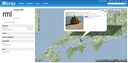
Here is the @trip interface showing some trips that I uploaded (one public, one private).
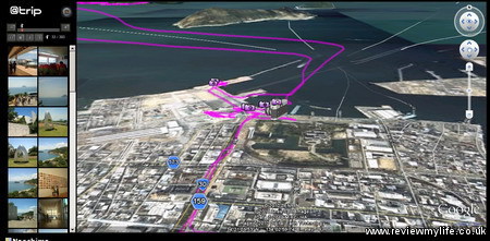
Once uploaded to the @trip server you can view the trip in a flat Google Maps view, or by using a 3D Google Earth view – this will be great if you are recording your mountaineering, or hand gliding adventure.
Rather than just looking at a static image of my @trip account your can have a look at the real thing showing a trip I made to Naoshima Island in Japan.
There is an option on the @trip server that allows you to embed a trip in your blog, such as I have done below.
Overall verdict of the i-gotU GT-600
This is a good GPS data logger with a long battery life, and large memory. The unit is small, easy to use, and has worked reliably during my two weeks of testing. The software makes it very simple to view your trips on your PC, geotag your photos, and share them all on the internet. I’m just hoping they release a software update to sort out the minor problems and bugs that I found.
Where to buy
If you are in the UK the GT-600 is available from this seller on Amazon, but last time I checked it was slightly cheaper from Maplin.
For more comprehensive information on where to buy the GT-600 around the world see Mobile Action’s – Where To Buy page.
Update: 15th September 2010 – @trip PC suite not loading issue
I started having a problem where @trip PC suite would not load (at all). But Sports Analyzer still loaded. I tracked it down to a corrupt sub folder in this resource directory – C:\Users\[username]\AppData\Roaming\Mobile Action\atrip\Resource. If you are having this same problem and want to try to track down which folder is corrupt.
- Backup the whole resource folder (C:\Users\[username]\AppData\Roaming\Mobile Action\atrip\Resource) so you can restore it later.
- Rename one of the sub folders in this directory and try restarting @trip PC. The corrupt one will probably be one of the ones you’ve edited most recently.
- Repeat until you find the corrupt one. You have found the corrupt one when @trip PC starts. However you’ll now see that in @trip PC all the trips belonging to the resource directories that you renamed have disappeared.
- Exit @trip PC.
- Now restore the whole resource folder from your backup, and then delete the corrupt sub folder.
- Restart @trip PC and you should have all your trips back (minus the corrupt one). You’ll have to recreate the corrupt trip if you want it back.
An extra bit of info if you are digging deeper: A list of the sub folders is stored in C:\Users\[username]\AppData\Roaming\Mobile Action\atrip\Resource\RESOURCE_INFO.INI. When you successfully manage to load @trip PC again it will delete the entries for the folders that you renamed. You need to restore from your backup (point 5 above) so @trip PC knows about the non-corrupt sub folders that you renamed.


Great Review, thanks for all the detailed information!
Great review. I have this as a gift -your review gives a much better idea of what you can do with it than the manual does! A couple of points not covered:
1 – How do you delete old trips so that new trips don’t just fill up the memory?
2 – If you are away for 3 weeks without your PC, how do you charge it up? Presumably buy a mains charger with a USB socket?
Hi BrianJ,
1. There is a ‘Clear Device Data’ button on the @trip PC UI. Also the device has a circular buffer recording mode, so it can automatically overwrite old data as new data is recorded. I prefer to delete old data though – it seems to sync faster and more reliably with the PC that way.
2. Yes the battery is sealed inside so you will need access to a computer or USB charger if you are away for a while.
does anyone know how long battery would last? 2h? 20h? 100h? even a rough estimate would be better than “20% more with motion detection”.
otherwise great review, thanks.
cpt jack – they claim the the battery lasts about 30 hours (I’m not tested this though). I’m not sure from their specs whether that is with the motion detection mode on or off. But I’m guessing that is with it on, as manufacturers usually quote the best possible battery life.
Thank you for this excellent revue.
Just a simple question before deciding to buy, is it possible to recover tracking data in a file format compatible with Excel ?
Hi Andre – you can export the data as a CSV (which you can view in Excel) as long as the data is still on the logger and it is currently plugged in. The software isn’t able to export the data as CSV from what is stored on the PC. For reference theses are the columns it exports.
Date, Time, Latitude, Longitude, Altitude, Speed, Course, Type, Distance, Essential
(I’ve no idea what the ‘Essential’ column is for!)
Thank you for your quick and accurate reply.
Another question popped up in my mind. The specification sheet on the manufacturer’s website claims the unit supports WAAS and EGNOS. I couldn’t find any confirmation of this in reviews or forums. If true, does it really improve accuracy (over western europe, mainly Belgium-France) without impairing sampling rate or battery discharge rate ?
Hi Andre, I can’t help you there – I’ve never heard of WAAS or EGNOS before, and I’ve only ever used this GPS unit in Japan.
Hi!
Could it be used on netbook as gps…in my car? So if i have a program as iGO can I use it as gps modul / navigation gadget?
Hi Bach – yes it can be used as a GPS if you connect it to a netbook. It can show your position on Google Maps, Bing Maps, or Yahoo! Maps. However you will need an in-car internet connection for your netbook for this to work. I’ve never tested this feature myself so I can’t vouch for how well it works.
What a great review and a fantastic product. Between the review and the comment replies I have all I need. Thank you
Hi,
Excellent review, great work, thanks for taking the time to write all this up, it’s very helpful.
I’m planning a trip to Canada this year and I’m looking for a device to track my movements and also use this data to geo-tag my photo’s while im out and about.
I’m going to be on the road for 3-4 weeks but not have access to a PC, so I take it I could charge this unit with a USB to mains adaptor but just wondering about the track recording if there is enough room for such a time frame?
Also are you able to export the tracks to GPX file format, I do this for my current tracks and upload these to my Google maps profile, can this be done?
Thanks,
Tim.
Hi Tim,
From the @trip PC application you can export the data as both GPX and CSV.
The unit can store 262,000 waypoints which should be 363 hours if you record one point per 5 seconds. You can adjust the recording frequency. I’ve never tried to record data of this size so I’ve no idea how reliable it is. The most I’ve recorded is 6-7 hours of data.
What is your experience of the accuracy of the altitude readings? My first experience, over an 8km route, is that it seems to wildly exaggerate altitude differences
Hi Rick, I’ve found all GPS units I’ve tried (including this one) are fairly useless at recording altitude. They only work well for longitude/latitude recording. The exception to this is if you are recording a plane journey – in this case the altitude recording can work.
Not quite happy to the sensitivity. I would love to record flight trips and it seems to be quite hard even the unit would be in contact to aircraft passanger window. I know I know, it’s aircraft glass but in same time my HTC Desire was able to record track.
I dont know if this IgotU GPS circuit has some altitude & speed restrictions for “not use it as military purposes” as the problems I had seems to be just on high altitudes and speed (33000ft @ 1100kmh ground speed). Anyone other noticed?
It’s very difficult to get info from the IgotU logger if you don’t use want to use the trip PC software. It would be much better if the company would respond to information queries, support request and the likes.
If you you need an easy way to obtain gpx data tracks without running there buggy software then look elsewhere.
Hi!
Does anybody knows what is the accuracy of the tag? Not for the altitude but for the latitude and longitude recording. Is it accurate on a centimeter scale, or meter scale? I cannot find any concrete figure about this on igotU website.
Thank you,
Pat
I am unable to reset the sampling time of my 600 to f.e. 15 seconds, the shift to do so does not work. I can set to a bit more than a minute by using the second lower shift but not the upper shift. Any idea to solve this?
Han
Hi!
Does anybody knows what is the accuracy of the tag? Not for the altitude but for the latitude and longitude recording. Is it accurate on a centimeter scale, or meter scale? I cannot find any concrete figure about this on igotU website.
Thank you,
Sai Kumar